
Getting Infrastructure Right Starts with the Land
Before roads, bridges, or utility lines take shape, one essential process comes first: land surveying services. It’s a step that often goes unnoticed but underpins nearly every construction and infrastructure project in the U.S.
This is where firms like Precision Surveying and Consulting step in — delivering precision surveys that ensure contractors and public entities can proceed with confidence. With operations in Nebraska, Iowa, Louisiana, Alabama, and Arizona, their reach and reputation make them one of the leading providers of professional land data services in the Midwest and beyond.
What Land Surveying Services Actually Include
Surveying is not a one-size-fits-all process. Precision Surveying and Consulting offers a variety of services tailored to the specific needs of infrastructure projects. These include:
Boundary Surveys – Confirm legal property lines and avoid future disputes.
Topographic Surveys – Map natural and man-made features to support design and engineering.
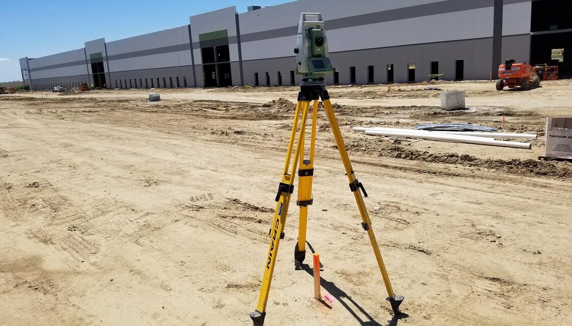
Construction Staking – Translate blueprints into physical layout points on the ground.
ALTA/NSPS Surveys – High-detail surveys for land title transactions, often required in commercial development.
3D Laser Scanning & Modeling – Provide engineers with highly accurate site models.
Ground Penetrating Radar (GPR) – Identify subsurface utilities or obstructions before digging begins.
These services are essential to reduce risk, support permitting, and ensure the site is ready for safe and accurate construction.
Multi-State Experience Makes a Difference
Working across five states means Precision Surveying and Consulting understands how regulations, soil types, and site conditions vary from one region to the next. Surveying a dry parcel in Arizona is a different task from managing floodplain compliance in Louisiana.
Because of this, the company adapts its approach based on geography, local laws, and engineering requirements. This flexibility is especially valuable for firms operating regionally or nationally who want consistency in service quality.
Omaha as a Center of Growth
One of Precision’s key service areas is Omaha, a city where infrastructure expansion has remained steady in both the public and private sectors. From highway realignment to warehouse development, projects here require consistent communication between surveyors, engineers, and project owners.
For clients in the area, working with experienced land surveyors in Omaha provides two major advantages: faster permitting and fewer revisions during the build phase. Precision’s ability to collaborate directly with local officials and engineering teams helps move site development forward with fewer headaches.
Trusted by Contractors and Agencies
Precision Surveying and Consulting works with a range of clients, including general contractors, engineering firms, public entities, and developers. What makes them stand out is their ability to integrate into a larger team, not just deliver a static report.
Their field crews are trained to handle changing conditions and complex site logistics. Meanwhile, their office team delivers CAD-ready files and documentation that align with architectural and civil design requirements. This reliability has helped them become known as not just a service provider but a surveying consultant.
Using Technology to Increase Accuracy
Surveying today is far more than a tripod and tape measure. Precision Surveying and Consulting uses advanced technology to streamline data collection and improve site accuracy:
GNSS (GPS-based surveying) improves precision over large distances.
Drones and aerial photogrammetry help map difficult or large terrain faster.
Laser scanning allows engineers to build models from existing structures or undeveloped land.
GPR is particularly helpful in infrastructure settings where underground utilities or unknown subsurface risks exist.
Technology doesn’t just make the job easier — it reduces human error and speeds up project timelines.
Reducing Risk Before the First Shovel Hits the Ground
Mistakes in site measurements can cost tens of thousands of dollars. Misplaced boundaries, uneven grades, and overlooked obstructions delay timelines and lead to rework.
The value of precision surveys comes from preventing those errors in the first place. With accurate land data, contractors avoid costly surprises, and engineers can design more efficiently.
Precision Surveying and Consulting’s methodical workflow — from pre-field research to post-survey QA — helps their clients break ground with confidence.
More Than a Vendor: A Strategic Partner
A trend in the industry is shifting toward collaboration over one-off transactional relationships. Precision is well-positioned here, as their team works closely with clients throughout the full life cycle of a project.
They assist with early planning, respond quickly to site changes, and stay involved until surveys are finalized and validated. This makes them a valuable partner on infrastructure projects where communication and adaptability are crucial.
Building Smarter Infrastructure, One Survey at a Time
As America continues to invest in infrastructure — whether roads, bridges, or new commercial corridors — the demand for accurate, efficient land surveying is only going to grow.
Precision Surveying and Consulting is ready for that challenge. With certified crews, modern tools, and experience across five states, they offer land surveying services that meet the needs of today’s most demanding infrastructure projects.
By staying focused on accuracy, collaboration, and adaptability, they are helping build the foundation for smarter, safer development — one survey at a time.
Elevator Spaces in Omaha is a great place for scaling businesses!
Amazing community and smart solutions for progress.
Cheer Athletics—St. Louis offers top-notch cheerleading classes, skilled coaches, and
a supportive environment. Perfect for any skill levels to shine.